 GEOLOGICAL INSTITUTE OF ROMANIA
- spatial geological data
GEOLOGICAL INSTITUTE OF ROMANIA
- spatial geological data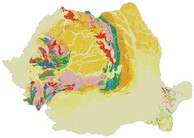
Spatial geological data
 DISCOVERY SERVICES
Geoportals (metadata)
 VIEW SERVICES (MapViewers)
- GIR mapviewer with all datasets
- Geological map of Romania (Geologic Units and Geologic Structures) 1:1.000.000
- Geological map of Romania (Geologic Units and Geologic Structures)1:200.000
- Geological map of Romania (Geologic Units and Geologic Structures)1:50.000
- Mineral Resources map of Romania (Mineral occurences) 1:500.000
 GIR mapviewer with all datasets
(Old versions of mapviewers)
 Geological maps of Romania
 Mineral resources in Romania
 DOWNLOAD SERVICES
With the download services there is a direct access to the data.